
OpenDroneMap (ODM) is the name of an open source toolkit for processing aerial drone imagery, developed by members of OSGEO, the Open Source Geospatial Foundation, that was started around five years ago and made quite some progress in the last year. It now offers modern photogrammetry technology for drones and other low altitude image collection such as balloons and kites and does fully automated matching, digital surface modeling and mosaicking. Stereo vision is used or creating orthophotos and maps, which is a process of extracting 3D information from multiple 2D views of a scene.
ODM follows a five-step photogrammetry workflow, that starts after aerial imagery has been captured by a drone that can do automated flights and is equipped with a GPS unit and camera. These drone images have to be offloaded into a PC with ODM software installed.
For the first step in this process, ODM uses the open sourced structure from motion software from Mapillary, a Swedish company that offers a platform for street view imagery with the same name. The software matches multiple pictures of the same space but from different angles together, creating 3D information from 2D images, resulting in a sparse point cloud where you can distinguish some objects and surface types.
The next step in the pipeline is cloud densification, meaning the creation of a more humanly understandable 3D space from the sparse point cloud. Dense algorithms produce a visually more attractive set of point clouds that distinguishes the different objects and surfaces in 3D. Next, the point clouds are transformed into a surface that can be textured over, using a triangulation method called ‘poisson’. This method is available through the Point Cloud library, a large scale, open project for 2D and 3D image and point cloud processing.
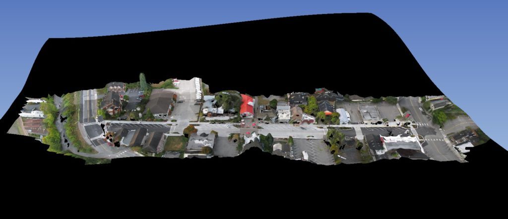
The final 3D mesh is textured next by overlaying images, using algorithms to determine which image is best for which area. Finally, an orthorectified mosaic is generated. With WebODM, users can view, inspect and download the orthophoto or 3D model online.
For more information, have a look to OpenDroneMap website.