- Building a 3D Digital Clock with ArduinoPosted 4 months ago
- Creating a controller for Minecraft with realistic body movements using ArduinoPosted 5 months ago
- Snowflake with ArduinoPosted 5 months ago
- Holographic Christmas TreePosted 6 months ago
- Segstick: Build Your Own Self-Balancing Vehicle in Just 2 Days with ArduinoPosted 6 months ago
- ZSWatch: An Open-Source Smartwatch Project Based on the Zephyr Operating SystemPosted 7 months ago
- What is IoT and which devices to usePosted 7 months ago
- Maker Faire Rome Unveils Thrilling “Padel Smash Future” Pavilion for Sports EnthusiastsPosted 7 months ago
- Make your curtains smartPosted 8 months ago
- Configuring an ESP8266 for Battery PowerPosted 8 months ago
Aweigh: the Open-Source Alternative to GPS

A team of student designers and engineers from the RCA and Imperial College have designed an open-source alternative to GPS, called Aweigh, that does not rely on satellites. It is a system that makes use of the space between objects to assist the person navigate. Aweigh can even work on a cloudy day when the sun is not in view, and unlike devices that use satellites, such as smartphones, Aweigh functions offline so a user’s positional data cannot be leaked through the internet.
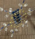
Aweigh is an open navigation system that does not rely on satellites: it is inspired by the mapping of celestial bodies and the polarized vision of insects. Ancient seafarers and desert ants alike use universally accessible skylight to organize, orient, and place themselves in the world. Aweigh is a project that learns from the past and from the microscopic to re-position individuals in the contemporary technological landscape.
The device’s custom circuit-board that reads light values to find the sun, is powered by Raspberry Pi, that is specifically designed to educate users about coding. The circuit board can be modified to customise interactions and the team imagine the device could work with older navigation tools like maps, and satellite navigation tools, by replacing the GPS chip.
The team is currently working on increasing the resolution, whilst the details for building the device yourself are available to download.






Pingback: The Most Ridiculously Expensive Factory Automobile Options | Our Right To Know