- makeITcircular 2024 content launched – Part of Maker Faire Rome 2024Posted 2 weeks ago
- Application For Maker Faire Rome 2024: Deadline June 20thPosted 2 months ago
- Building a 3D Digital Clock with ArduinoPosted 7 months ago
- Creating a controller for Minecraft with realistic body movements using ArduinoPosted 7 months ago
- Snowflake with ArduinoPosted 8 months ago
- Holographic Christmas TreePosted 8 months ago
- Segstick: Build Your Own Self-Balancing Vehicle in Just 2 Days with ArduinoPosted 8 months ago
- ZSWatch: An Open-Source Smartwatch Project Based on the Zephyr Operating SystemPosted 9 months ago
- What is IoT and which devices to usePosted 9 months ago
- Maker Faire Rome Unveils Thrilling “Padel Smash Future” Pavilion for Sports EnthusiastsPosted 10 months ago
GSM localizer without GPS – Part 2
Our Project
Regardless of how Google has compiled its database, once we discovered how cell phones using Google Maps Mobile send their requests, we immediately thought of employing that functionality to build a specific remote localizer, which, unlike those that have been proposed so far, relies solely on GSM/GPRS for its radio connection, rather than use a GPS receiver.
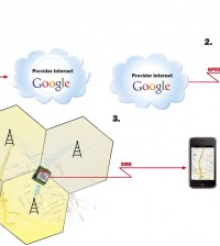
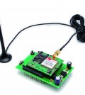
Well, here it is! This article describes our new localizer, which has numerous advantages over those using a GPS receiver, though it does not guarantee the same precision as they do. For one thing, our localizer is lighter and slimmer, since it lacks one of the pieces of the other phones. It is also less expensive, and most important, it lasts longer, given that it does not have a GPS receiver, which is the component that consumes the most energy. This means that one 1-Ah lithium battery, for instance, allows our localizer to work for several days (depending on the number of calls), while a 13-Ah battery will make it work for a couple of months. In addition, a localizer based on a cellular network is likely to pick up more quickly than a conventional phone: there are times when a GPS receiver may need a few minutes to determine its own position, whereas cellular network data allow for a speedy answer to the call to the Google server. What’s more, our cell phone has reception even in many highway tunnels and basements where a GPS receiver has no reception whatsoever. Before looking more closely at the localizer circuit, it is important to note that, due to the work of the many people engaged in developing cellular localization, several websites have popped up where one can find a large number of data regarding the position of the cells available for free. And there are also services available at a charge; one such service is provided by OctoTelematics (www.octotelematics.it), which features a carefully guarded database known for its thoroughness. Among the free websites we have found, two are worth mentioning: www.opencellid.org and www.celldb.org; in both of them, you can not only find valuable information, but also check the position of a cell by simply entering its identifier (Cell ID). Bear in mind that you can also manually get the identifier from the cell phone itself: All you need to do is install programs such as Nokia Net Monitor or WM Cell Catcher, a Windows Mobile service pack we have used to verify the data we sniffed during the communication between out cell phone and the Google server. Notably, www.opencellid.org makes APIs available; some of them allow users to download information on cells needed for localizing purposes, while at the same time providing the site itself with data, drawn from those users, on the position of new cells. For instance, when a GPS cell phone connects to a cell, its ID code and position can easily be obtained and transmitted to the site, which, in turn, will verify and publish them in behalf of all site’s visitors. The same site contains a thread that, utilizing Google Earth, shows how many and what cells are found in each area, distinguishing them by MCC and MNC. Regarding company codes, keep in mind that in Italy MNC 1 identifies TIM, 10 Vodafone, 88 Wind and 99 Tre (H3g). The file can be downloaded by clicking on Google Earth in the “Browse Cells” section of www.opencellid.org. However, one needs to first download and install Google Earth from www.google.com; once the plug-in has been installed, the heading “View Cells” is displayed in the Google Earth Places panel, under “Temporary Places.” At any rate, while developing our application, we relied on data provided by Google Maps Mobile, given that, unlike other sites, Google provides information regarding not only the conjectured but also approximate position of a cell phone; in other words, it indicates how far a cell phone can possibly be in relation to any given point. Among others, the closest possible position is indicated. Note that at the moment Google does not employ the triangular method, that is, the capability of obtaining data from neighboring cells, which would allow to determine a given position more precisely, nor does it verify the strength of the cell signal, since that could be misleading. Indeed, determining the distance from the cell on the basis of how strong its signal is does not necessarily provide accurate information, as the reception can be hindered by a number of factors, such as weather conditions and even radioelectric disturbances. Our localizer runs on batteries, so it can be carried by those who feel they may need to call for help or to be easily reachable by others; however, it can also be used in vehicles (without having been installed) or simply be part of moving goods . In a nutshell, it can do whatever a localizer can do, short of telling us which side of the street it is on; yes, that is something it cannot do, though it can definitely help us figure out whether a driver is going the right direction or is ending up in a different neighborhood in some town nearby. In order to save battery life, we have set up our localizer to provide its position when requested via SMS, by means of a call or periodically; we have also implemented an SOS function, which can be activated by pressing a button: an SMS requesting help, and containing the coordinates of the relevant position, is immediately sent to the number that has been stored. More specifically, up to eight numbers can be stored from phones that can send out SMS messages; to this end, a phone call will do, too, although this call won’t be answered in order not to spend money. When asked, the localizer will send an SMS with the current localization result. When in auto-report mode (that is, sending periodic notifications), it sends SMS messages with localization data to one or more of the stored numbers, depending on the user’s settings. Please see the drawing for details of how it works. Basically, if we want to find out the position of the remote device, we must send it an SMS. Once the message has been received, the device verifies the data of the cell it is connected to and sends Google a request via GPRS; in turn, Google will send back the coordinates together with data regarding how precise the information is. As soon as the device receives this information, it forwards it to us by means of another SMS. All of this takes but a few seconds.
HOW IT WORKS
a) sends an SMS to the localizer
b) localizer verifies the cell linked and sends a request via GPRS to Google
c) Google sends back the coordinates together with data regarding precision
d) when the Localizer receives this information, it forwards it to us by another SMS


